
Grandfield
Historical
Society
the
presents
A Concerted Production by
THE GRANDFIELD HISTORICAL
PRESERVATION COMMITTEE
Site Menu
Maps
A Comprehensive List of All Maps on this Website (To go automatically to any map, click the button to the left of that map below).
Detailed Satellite Image
Full Width Satellite Image


Map of the United States : drawn from the most approved surveys. 1826
Starr & Co.
New York : I. Starr & Co., 1826.
Repository
Library of Congress Geography and Map Division Washington, D.C. 20540-4650 USA dcu
Digital Id
http://hdl.loc.gov/loc.gmd/g3700.ct003952
Library of Congress Control Number
2007626857
https://www.loc.gov/item/2007626857/
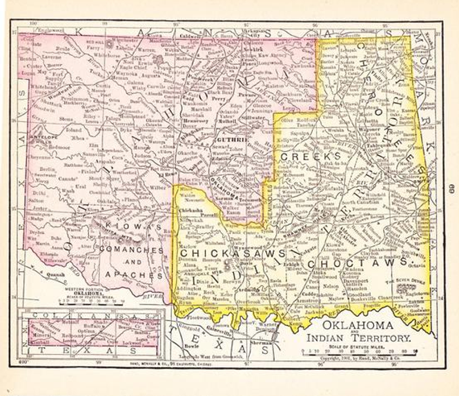
Early Map of Indian Territory
:


Map Demonstrating Territorial Growth from 1775 to 1820

Reynolds's political map of the United States, designed to exhibit the comparative area of the free and slave states and the territory open to slavery or freedom by the repeal of the Missouri Compromise. Also referred to as Political map of the United States
Contributor Names
Reynolds, William C. & Jones, J. C.
Created / Published
New York : Wm. C. Reynolds and J.C. Jones, c1856.
Library of Congress Geography and Map Division Washington, D.C. 20540-4650 USA dcu
Digital Id: http://hdl.loc.gov/loc.gmd/g3701e.ct000604
Library of Congress Control Number: 2003627003
https://www.loc.gov/resource/g3701e.ct000604?r=-0.208,0.112,1.335,0.699,0

Indian tribes, reservations and settlements in the United States
Attahvich, Sam.
United States. Office of Indian Affairs.
Library of Congress -
https://www.loc.gov/item/2009579474/
[Washington, D.C.] : Dept. of the Interior, Office of Indian Affairs, 1939.
Library of Congress Online Catalog (977,238)
https://loc.gov/ = Library of Congress WEBSITE'
http://www.loc.gov/law/help/statutes-at-large/64th-congress/session-1/c64s1ch304.pdf


Possibly the Earliest Map Defining Indian Territory

Map of the Platte Purchase
1820
The Platte Purchase was a land acquisition in 1836 by the United States government from American Indian tribes. It comprised lands along the east bank of the Missouri River and added 3,149 square miles (8,156 km ) to the northwest corner of the state of Missouri.
This expansion of the slave state of Missouri was in violation of the Missouri Compromise of 1820, which prohibited the extension of slavery in the former Louisiana Territory north of the parallel 36°30′ north except within the boundaries of the state of Missouri as defined at the time of the adoption of the Missouri Compromise. The area acquired was almost as large as the states of Delaware and Rhode Island combined, and extended Missouri westward along the river. St. Joseph, one of the main ports of departure for the westward migration of American pioneers, was located in the new acquisition.

Denoting Oklahoma and Indian Territories

1890 - U S Native American Linguistic Stocks and Tribal Areas

First Official Map of the State of Oklahoma

Map of Comancheria

Map Showing Native Lands in Indian and Oklahoma Territories 1834-1907

Early Tillman County Map - to the right, the Act of Congress allowing the sale of Indian Lands for the Cemetery or farm land within the township? 1916
Act of Congress providing sale of Indian Lands in Oklahoma, specifically Tillman County and Grandfield.
SIXTY-FOURTH CONGRESS. SESS. I.
Crs. 304-306. 1916.
445
CHAP. 304.-An Act To provide for the sale of certain Indian lands in Oklahoma, and for other purposes.
Be it enacted by the Senate and House of Representatives of the UnitedStates of America in Congress assembled, That the Secretary of the Interior is hereby authorized and directed, upon application therefore to sell to the county of Tillman, State of Oklahoma, at $1.25 per acre, not exceeding one hundred and sixty acres, for county farm purposes, and to the town of Grandfield, Oklahoma, not exceeding forty acres, for cemetery purposes, of vacant undisposed of lands within the town-site reserves in the State of Oklahoma, withdrawn by Executive orders under the Act of March twentieth, nineteen hun-dred and six (Thirty-fourth Statutes at Large, page eighty), the money received from the sale of said lands to be deposited in the Kiowa Indian Agency Hospital Fund, and to draw interest at therate of four per centum per annum.
Augst 9,1916.and for other purposes. [H. R. 11958.][Public, No. 186.1
Approved, August 9, 1916
[H. R. 11958.][Public, No. 186.1
Vol. 34, P.80

Early Tillman County Schools Districts and Locations
Click Here for Complete List and Locations

Grandfield Grid Mapping
(Not Zoomable - Refer to Google Map above :)
Now THIS is a MAP! This map is TOTALLY zoomable, you can drag the image around and even go to a street-level view using the little guy to return once you have seen your house and stuff! Go on, try it!

Cotton County Schools
For a Complete listing...

Indian reservations within the limits of the United States - 1892
United States. Office of Indian Affairs, Morgan, T. J. (Thomas Jefferson), 1839-1902.
Washington, D.C. : Office of Indian Affairs, 1892.
Library of Congress Geography and Map Division Washington, D.C. 20540-4650 USA dcu
LOC ID: http://hdl.loc.gov/loc.gmd/g3701g.ct002305
Found at: https://www.loc.gov/item/2009579467/
.jpg)
Grandfield & Loveland Area School District Locations

Early Maps Showing "Camp Augur"
Enlargement of the Indian Territory Map Below c.1850


National Registry of Historical Places Details

